REVIEW · OAXACA CITY
Sierra Norte Hike and Indigenous Village Full-Day Adventure
Book on Viator →Operated by Valterra Excursiones · Bookable on Viator
Some days you need a mountain day.
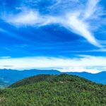
This full-day Sierra Norte hike trades Oaxaca City streets for cool air, pine forest trails, and village life around Cuajimoloyas, guided by Ivan plus a local community guide. You’ll start at the Templo de San Matías Jalatlaco, drive up into the mountains, then spend about 3.5 hours hiking through crevasses, rock walls, and plant-rich paths before ending back in town.
What I like most is how this tour mixes movement with real place: you get a chance to spot native plants like ferns and giant agaves, and you also sit down for included meals that feel like someone’s home cooking. My other favorite detail is the pacing: it’s moderate (not a grindy all-day scramble) but still has hands-on moments and a 100+ meter suspension bridge stretch for those who want the extra thrill.
One drawback to plan around: you’ll be at high elevation, the hike is about 8+ km, and it’s not a fit if you have low fitness, respiratory issues, or mobility limitations.
In This Review
- Key takeaways before you go
- Meeting in Jalatlaco and why the day starts in the right place
- The 90-minute mountain drive: comfort now, big views later
- Breakfast in the mountains: memelas and coffee that actually fuel the hike
- Starting the hike at Cuajimoloyas: moderate means steady, not casual
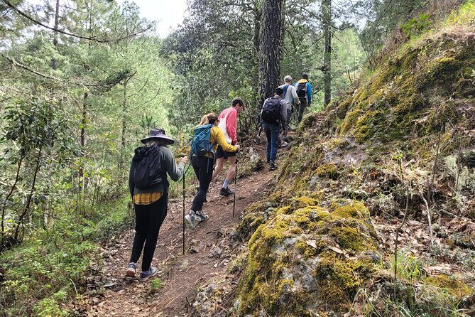
- Where the trail delivers: pine forest, crevasses, and rock-wall moments
- Plant spotting and bird calls: why the guide changes the hike
- The suspension bridge: the 100+ meter payoff (and the extra cost)
- Lunch in Cuajimoloyas: homemade mountain cuisine and a real community feel
- Getting back to Oaxaca City: a calm finish instead of a rushed scramble
- Who this tour is best for (and who should skip it)
- What’s included (and what you’ll handle yourself)
- Practical tips that make the day smoother
- Value check: does $107.54 feel fair?
- Should you book the Sierra Norte Hike and Indigenous Village day?
- FAQ
- What time does the tour start and end?
- Where do I meet the guide?
- How long is the hike, and what distance should I expect?
- Is the hike difficult?
- What meals are included?
- Is the suspension bridge included?
- What does the tour include besides the guide?
- Who should avoid this hike?
Key takeaways before you go
- Small group (max 6) with a guide who keeps the day organized and paced.
- Breakfast + lunch included from local mountain comedores (memelas and coffee in the morning).
- 8+ km moderate hike with elevation gain around 250+ m and a few hands-and-feet spots.
- Pine forest plus crevasse and rock walls makes the trail feel varied, not repetitive.
- 100+ meter suspension bridge option costs extra (70 pesos) so decide in advance.
- High-altitude cold is real—layers help, even if Oaxaca City feels warm.
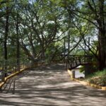
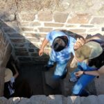
Meeting in Jalatlaco and why the day starts in the right place
You begin in Jalatlaco, meeting at the front of the Templo de San Matías Jalatlaco at 8:00 am. That early start matters. First, it helps you beat the day’s crowds in Oaxaca City. Second, it sets a calm rhythm before the mountain drive—less rushing, more time to get settled with your guide.
If you’re the kind of person who enjoys travel that feels anchored in everyday local life, you’ll appreciate that the day starts with a recognizable neighborhood landmark rather than a generic “tour bus” pickup point. It’s a small detail, but it helps your brain shift into travel mode.
From there, you’ll head north by van in an air-conditioned ride—useful because once you’re leaving the city, the weather can change fast. The route time is about 90 minutes to reach Cuajimoloyas.
You can also read our reviews of more hiking tours in Oaxaca City

The 90-minute mountain drive: comfort now, big views later
That drive is longer than you might expect for a day tour, but it’s part of the value. You’re paying for time in the van plus interpretation from the bilingual guide. You don’t just get transported; you get set up for the day ahead.
At Sierra Norte altitude, the temperature can shift and the air feels different. A calm drive means you arrive having energy for breakfast and a hike. It also makes it easier for you to pace yourself once you start climbing—because elevation is the real boss here, not technical skill.
This is also a good moment to ask questions. If you’re curious about the plants you’ll see later, the guide can flag what to watch for. In the best cases, you’ll notice more on the trail simply because you were primed to look.
Breakfast in the mountains: memelas and coffee that actually fuel the hike
Before you hike, you’ll stop for breakfast in the mountains, with about 45 minutes on the schedule. Breakfast includes local items—specifically memelas and coffee.
This matters more than it sounds. The hike is around 8+ km total and about 3.5 hours on foot (moderate, with intermediate skill). If you try to “breakfast later” or you skip food because you’re not hungry, the elevation will remind you quickly. Having a proper start also makes the afternoon lunch feel better, not like a rushed finish.
I like that the breakfast isn’t packaged. You’re eating at a local eatery in the mountains, which means your morning tastes like the region instead of like a generic tourist menu.
Tip: if you’re sensitive to cold, you might be happier with warmer layers at breakfast. It can feel cooler once you’re up.
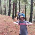
Starting the hike at Cuajimoloyas: moderate means steady, not casual
The hike begins at Cuajimoloyas with about 3.30–4 hours of hiking time for the main trail portion. The total distance is 8 km / 5 miles approx. (plus/minus a bit depending on the exact route taken). Elevation ranges roughly from 3,050 m minimum to 3,230 m maximum, and you’ll gain around 250+ m elevation (the day also includes segments that feel like a bit more, depending on trail details).
The skill level is described as intermediate and the difficulty as moderate—so here’s what that usually means on the ground:
- You should be comfortable walking uphill for long stretches.
- Expect a few sections where you may need your hands as well as your feet.
- You can take breaks, but you can’t treat it like an easy stroll.
One practical way to judge fit: if you can handle a 90-minute hike at home that feels mildly challenging, you’re likely in the right neighborhood. If you’re currently dealing with stamina issues, the altitude may make everything feel harder. And if you have respiratory concerns, this one is not recommended.
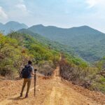
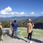
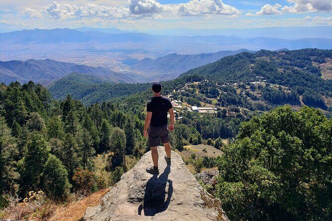
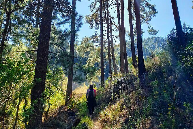
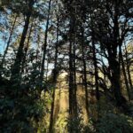
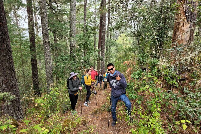
Where the trail delivers: pine forest, crevasses, and rock-wall moments
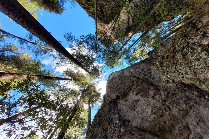
The trail is varied on purpose, so you won’t just hike through the same forest tunnel the whole time. You’ll move through pine forest trails, and the route includes sections described as a crevasse and tall rock walls.
In the moments that sound intimidating on paper, the key is that they’re short and guided. On this kind of hike, the guide’s job is not to show off—it’s to help you find the safest path and keep your pace steady. That’s also where your confidence jumps. You’ll likely realize the “hard-looking” section is manageable because you’re not alone and the group is moving in a controlled way.
In real-world terms, some parts can involve brief scrambling-like movement. A few reviews-based details you should keep in mind: there can be at least two hands-on segments—one involving an ascent through a narrow slit between rock faces, and another climb up to a top viewpoint where you take a water break.
Those parts are memorable because you feel connected to the terrain, not just passing through it.
You can also read our reviews of more tours and experiences in Oaxaca City
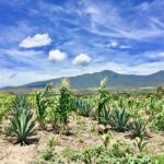
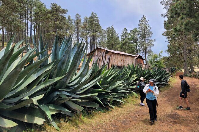
Plant spotting and bird calls: why the guide changes the hike
This is one of the big strengths of the day. The guide doesn’t just point out scenery; they identify plants and help you notice what’s alive around you. You’ll spend time learning about native plants, including ferns, giant agaves, and wildflowers.
Even if you don’t care about botany, this kind of stop makes the hike easier mentally. You’re not just counting steps. You’re switching gears to look closely. That reduces the sense of fatigue and turns the trail into something active and interesting.
Bird spotting is also part of the experience. You may hear birds more than you see them, and the guide can help you connect what you’re hearing to what you’re actually looking at. One bird that has been spotted on the trail is a red warbler, which gives you a concrete example of the sort of wildlife attention you might get.
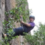
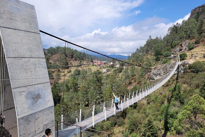
The suspension bridge: the 100+ meter payoff (and the extra cost)
At some point, you’ll reach the 100+ meter suspension bridge. This is a true “I’m here” moment: you’re up high, you’re crossing a long span, and the air feels different when you move out over open space.
But there’s a key detail: access to the suspension bridge costs 70 pesos, and that’s not included. The tour schedule gives about 30 minutes for this part, which suggests you’re not meant to sprint across—you’ll have time to cross slowly, take photos, and reset your footing.
My practical take: if you don’t want to pay extra or you’re worried about vertigo, you can consider skipping it. If you’re curious and steady on your feet, it’s worth budgeting for because it turns the hike into a unique story, not just a nice walk.
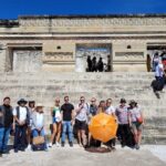
Lunch in Cuajimoloyas: homemade mountain cuisine and a real community feel
After hiking, you’ll return to the village for lunch with about 45 minutes set aside. Lunch is included and described as authentic, homemade mountain cuisine.
This is where the day becomes more than exercise. You get a break in a village comedor setting. The food is often simple but filling, and it tends to feel homey rather than fancy. You can also use this meal to fully recover before the drive back.
If you like travel that supports local places, look for the role of the local community guide. The day is designed with community involvement, and that’s part of the emotional value: you’re not just consuming a view—you’re interacting with the people who live there.
Getting back to Oaxaca City: a calm finish instead of a rushed scramble
After lunch, you start the drive back toward Oaxaca City and finish around 4:30–5:00 pm, depending on traffic and how the group moves. The return drive is about 1.5 hours.
This finish time is helpful because it gives you the rest of your evening for something easy. You’re not likely to get stuck with a late-night return that wrecks dinner plans. You’ll likely feel tired, though. That’s normal after elevation and a solid 3.5-hour hike.
Who this tour is best for (and who should skip it)
This hike is a good match if:
- You want an active day in the mountains north of Oaxaca City.
- You’re comfortable with moderate hiking and a total distance around 5 miles.
- You like nature stops where you learn about plants, birds, and how the landscape works.
It’s not a great match if:
- You have low fitness, since the elevation can steal your breath fast.
- You have respiratory issues, since altitude isn’t negotiable.
- You have mobility impairments, because it’s not recommended and the trail includes hands-on sections.
- You’re expecting a gentle, flat walk—this is more work than that.
One more thing: the day runs long enough that you should treat it like a full outing. Bring stamina, not just enthusiasm.
What’s included (and what you’ll handle yourself)
Included:
- Professional bilingual guide
- Air-conditioned private transportation
- Park entrance fee included
- Breakfast and lunch
- Bottled water plus drinking water to refill your bottle
- Hiking poles
- Local community guide
Not included:
- Suspension bridge access (70 pesos)
This is a well-balanced setup for value. You’re getting transport, interpretation, admission, meals, and core gear (poles). That reduces decision fatigue. The one “extra” is the bridge, and honestly that’s easy to plan for once you know it costs 70 pesos.
Practical tips that make the day smoother
Here are the details that matter most for a day like this.
Dress for cold and altitude
Even if it feels mild in Oaxaca City, once you’re higher up, you can get cold quickly. Layers help a lot. Reviews-based experience also suggests you should be ready for rain or drizzle. If that happens, a guide may have small extras like ponchos, but you shouldn’t rely on that. Pack your own layers.
Bring comfortable shoes
This is a hiking day with uneven ground and at least a couple hands-on moments. You want footwear with grip and ankle support you trust.
Pace like you live there
The altitude can make normal effort feel harder. Use the guide’s pace, take the breath breaks, and don’t try to “win” the trail. You’ll enjoy it more, and you’ll likely feel less wiped out at lunch.
Decide early if you want the bridge
If the 70 pesos extra cost feels like a hassle, you can treat it as an optional add-on. If you enjoy crossing bridges and want that big photo memory, plan to pay.
Value check: does $107.54 feel fair?
At $107.54 per person, you’re not paying for a cheap casual hike. You’re paying for a full day with real logistics:
- a private air-conditioned van
- a bilingual guide
- park access included
- breakfast + lunch
- hiking poles
- help from a local community guide
When meals are included, that’s real savings. When admission and transport are included, you avoid surprise costs and scheduling hassles. And because the group max is 6 travelers, it’s less chaotic than bigger bus-style outings.
The bridge cost is the one notable add-on, and at 70 pesos it’s relatively small in the bigger picture. The main “cost” here is effort: you should show up ready for a moderate climb at high altitude.
If you want a day that feels like you stepped into Sierra Norte life (not just walked through it), the pricing structure makes sense.
Should you book the Sierra Norte Hike and Indigenous Village day?
If you’re choosing between a city day and an outdoors day, I’d lean outdoors for this one—especially if you like hands-on nature, plant identification, and village meals that feel real. The combination of small group size, strong guiding, and included food makes it a solid value.
Book this hike if:
- you can handle 3.5 hours of hiking and about 5 miles total
- you enjoy learning as you go (plants, birds, village culture)
- you want a mountain day that ends before the evening chaos starts
Skip it if:
- your fitness level is low right now
- you have respiratory concerns due to altitude
- you need a low-impact route and mobility support
FAQ
What time does the tour start and end?
It starts at 8:00 am and finishes back at the meeting point around 4:30–5:00 pm.
Where do I meet the guide?
You meet at the front of Templo de San Matías Jalatlaco, Miguel Hidalgo 211, Barrio de Jalatlaco, 68080 Oaxaca de Juárez.
How long is the hike, and what distance should I expect?
The hike time is about 3:30 hours (approx.) and the distance is around 8 km / 5 miles (approx.) total.
Is the hike difficult?
It’s listed as moderate, with an intermediate skill level. You should have moderate physical fitness.
What meals are included?
Breakfast and lunch are included. Breakfast includes memelas and coffee, and lunch is homemade mountain cuisine.
Is the suspension bridge included?
The suspension bridge is not included. Bridge access costs 70 pesos, and it’s optional.
What does the tour include besides the guide?
You get a bilingual guide, private air-conditioned transportation, park entrance fees, bottled water for drinking and refilling, and hiking poles. There’s also a local community guide.
Who should avoid this hike?
It’s not recommended for travelers with mobility impairments or respiratory issues, and it’s best for people with at least moderate fitness.